


Sophia Goldberg staff writer
A rare, unpredictable guest will soon be knocking on our Pacific Coast, with the gift of much-needed rain. El Niño in 2015-2016 is predicted to come as one of the strongest El Niño storms ever recorded.
El Niño, as defined by the National Oceanic and Atmospheric Administration (NOAA), is a two to seven year weather phenomenon when a sea surface temperature anomaly of 0.5°C or greater is observed in the Niño 3.4 region and that the 3-month Oceanic Niño Index (ONI) threshold will be met. This major storm has a 95 percent chance of occurrence during the late fall and winter of 2015-2016 through the spring of 2016.
The El Niño Southern Oscillation Diagnostic Discussion page from NOAA states that across the continental United States, the temperature and precipitation impacts associated with El Niño are not expected to kick in until the late fall and winter. El Niño will likely contribute to a below-normal Atlantic hurricane season and to above-normal hurricane seasons in both the central and eastern Pacific hurricane basins.
According to NOAA, El Niño winters are two to three times stronger than normal conditions. In Southern California, the probability of precipitation will increase by 40 to 50 percent through the winter.
The rain that may come this winter could put a big stop on the construction beginning second semester. Principal David Jackson believes that if this rain does come, the construction plan could be severely delayed.
“If that rain actually comes, it will affect the construction a lot. For example, we can’t lay asphalt if the ground is not dry and compressed down. The lacrosse field will not be able to be covered in asphalt to put the bungalows on in time if the rain comes early,” Jackson said.
Jackson says there are talks about a modification to the remodel plan, that would help both students and the problems when the rain comes.
“We are looking to change the process of the remodel of the school. It may not be the whole school at one time; instead we would do the construction in phases. We don’t know for sure if this is happening because board approval is needed. We may not lose parking for our students, and that is a big issue for our students. This modification will definitely help with the rain since only part of the building will be remodeled at a time,” Jackson said.
While Jackson believes that the rain can bring many problems and delays to the construction plan, Superintendent Steve Kessler thinks that the only real concern regarding the rain is filtering the runoff away from the construction zones during the modernization.
“Before any type of construction begins, a drainage plan has to be submitted, then reviewed by the Department of State Architecture. In the event of an El Niño event or heavy downpour, a plan would have already been put into effect that would take care of the runoff. I’m not worried about once the building is constructed and the drains are set in place, the biggest issue its what’s going to happen during the construction. There is an actual plan that has to be submitted stating how you’re going to take care of all this runoff during construction…You can’t be building things in the rain. For example, you can’t do concrete because the rain will mess up the mixture, and you can’t have a bunch of power tools in the rain for obvious electrical concerns. Within every plan, they actually put in rain days. Even though we say a building will be finished in nine months, they’ll actually say it will take 10 months to build, because they build into it a month of rain delays,” Kessler said.
Kessler believes that the parking issue will not be affected by the rain at all, as students may still have parking at the high school, or in the surrounding areas, and these students will not have to walk through the rain to get to and from school.
“An idea that is being floated around by the Board of Education is to possibly not start building A. Building A is that back building that houses all the parking. The Board is considering holding off on completing building A, which would mean you would keep the student and teacher parking, and parking will become a nonissue. I am hoping the Board will move ahead with that idea, because then we won’t have parking issues, but let’s say the Board continues with the current plan for building A. We have already reached out to property owners in Beverly Hills and Century City to ask them if we could possibly rent their parking lots for the two and a half years plus that it would take to redo our parking,” Kessler said.
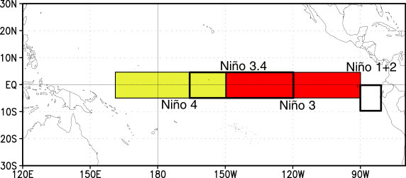 El Niño is divided into four regions in the equatorial Pacific Ocean, as shown in the figure to the left. These zones are Niño 1+2, Niño 3, Niño 3.4, and Niño 4. In total, they stretch from the western coast of South America to the eastern coast of Australia.
Sea surface temperature (SST) anomalies are taking place throughout the Pacific Ocean. Ocean temperatures are increasing in the Niño 3.4 and Niño 3 regions, are unchanged in the Niño 4 region and are decreasing in the Niño-1+2 regions. The graph below shows the fluctuations in the ocean temperatures in each region.
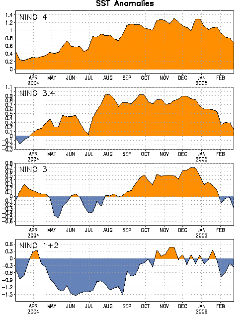
During the summer, ocean temperatures along the eastern Pacific have reached an increase in sea surface temperature of up to 1.22°C. This is the third-highest summer ocean temperature since records started in 1950, behind 1987 (1.36°C) and 1997 (1.42°C). In August, the ocean temperatures in the eastern Pacific have raised to 1.49°C, second to the August of 1998 (1.74°C).
Wind patterns are very diverse over the Pacific Ocean. There are trade winds and westerlies involved with this weather phenomenon.
Normally, the trade winds, also known as easterlies, blow northwest over South America, while the westerlies, blow southeast closer to the polar regions.
During El Niño, these trade winds are weaker, and the warm water that is normally in the western Pacific, near Asia and Australia, flows to the colder eastern Pacific. This process is completed by the diffusion of heat from a warmer body to a colder body, and the eastern Pacific Ocean warms. Also during El Niño, the westerlies become slightly stronger, helping move the warm water from the Western Pacific to the eastern Pacific.
The wind abnormalities mentioned above are beginning to take place. The low-level westerlies are becoming slightly stronger and more common. The easterlies are becoming weaker and more irregular.
According to NOAA’s Climate Prediction Center, these irregularities began to occur in late-April, as the wind and temperature associated with El Niño had begun to appear. During mid-August of this year, the warmer waters have already begun to flow over to the Eastern Pacific. These warmer waters have already reached Hawaii.
Categories:
El Niño brings rain to Southern California
September 25, 2015
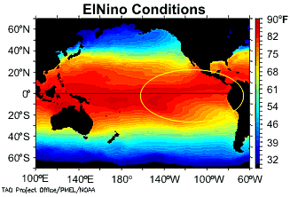
Here, you can see the sea surface temperatures of the Pacific Ocean during El Nino. Photo courtesy of: noaa.gov
Donate to Highlights
$125
$1000
Contributed
Our Goal
Your donation will support the student journalists of Beverly Hills High School. Your contribution will allow us to purchase equipment and cover our annual website hosting costs.
More to Discover